


Quick Info — Kamanbaneng Peak & Kaman-Utek Hills Complete Hiking Guide 2025
| Location | Itogon, Benguet, Philippines |
|---|---|
| Best time to visit | Dry season, November–May; early start recommended |
| Duration | Half to full day; full traverse is long |
| Difficulty | Moderate to strenuous; steep ascent and ridge exposure |
| Getting there | Bus/van to Itogon, Baguio, then local transport to trailhead |
| Fees | Registration and guide fee typically required |
| What to bring | Trekking shoes, extra water, headlamp for early start, gloves for trails, cash |
Table of Contents
Quick Facts About Kamanbaneng Peak (Marlboro Hills)
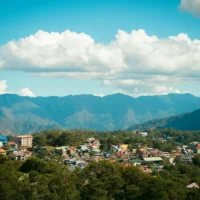
Kamanbaneng Peak, locally known as Marlboro Hills, stands as one of Sagada’s premier sunrise viewpoints. Located in Mountain Province, this accessible summit offers breathtaking 360-degree views of the Cordillera mountain range and the famous “sea of clouds” phenomenon.
Essential Details:
- Elevation: Approximately 1,500 meters above sea level
- Difficulty Level: Easy to moderate (suitable for beginners)
- Hiking Duration: 45 minutes to 1 hour from jump-off point
- Best Time: Early morning for sunrise (5:30-6:30 AM)
- Trail Type: Well-maintained dirt path through pine forests
The peak gets its nickname “Marlboro Hills” from the rolling landscape that resembles scenes from classic cigarette advertisements, though the natural beauty here far surpasses any commercial imagery.
Planning Your Kamanbaneng Peak Sunrise Trek
When to Start Your Hike
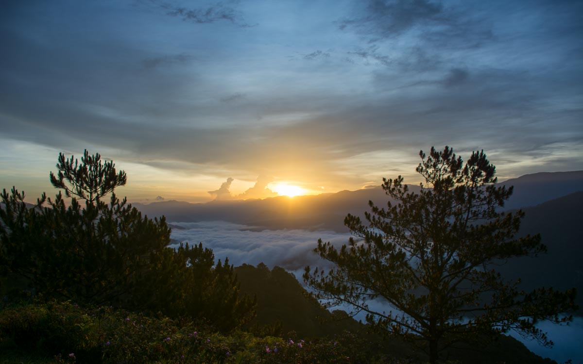
Timing is everything for a successful sunrise trek to Kamanbaneng Peak. Start your journey around 4:30-5:00 AM to reach the summit comfortably before sunrise. The golden hour typically begins around 6:00 AM, with full sunrise occurring by 6:30 AM, depending on the season.
Our group gathered in the hostel lobby at 4:15 AM, allowing time to meet our guide and make the short jeepney ride to the trail head. The early start might feel challenging, but watching the sun paint the mountains in golden hues makes every lost minute of sleep worthwhile.
What to Bring for the Trek
Essential Items:
- Warm jacket or windbreaker (morning temperatures can drop to 10-15°C)
- Comfortable hiking shoes with good grip
- Headlamp or flashlight for pre-dawn hiking
- Water bottle and light snacks
- Camera with extra batteries
- Small backpack for essentials
Optional but Recommended:
- Drone (if you have permission and experience)
- Portable phone charger
- Cash for summit refreshments
- Tripod for photography
Weather Considerations
Sagada’s mountain climate can be unpredictable, especially during early morning hours. The best months for clear sunrise views are typically March to May and October to December. During rainy season (June to September), expect muddy trails and potential cloud cover that might obscure sunrise views.
Check weather conditions through the Philippine Atmospheric, Geophysical and Astronomical Services Administration (PAG-ASA) before planning your trek.
Step-by-Step Hiking Guide to Kamanbaneng Peak
Getting to the Jump-off Point
From Sagada town proper, take a jeepney ride to the Marlboro Hills jump-off point. The 10-15 minute ride costs approximately ?50-100 per person, depending on group size and negotiation skills. Your guide can arrange transportation as part of the package.
We decided to take the jeepney option to conserve energy for the actual hike, though some adventurous visitors choose to walk the entire route from town.
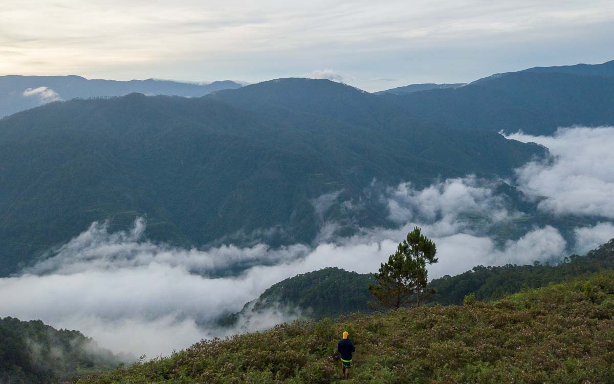
The Trail Experience
The trail to Kamanbaneng Peak follows a well-defined dirt pathway that winds through stunning pine forests. Despite being classified as “easy,” expect some moderately steep sections and potentially muddy conditions, especially after rainfall.
Trail Highlights:
- Dense pine tree corridors providing natural shade
- Small stream crossings with makeshift log bridges
- Rocky outcrops offering preview glimpses of the summit views
- Native flora including wild berries and mountain flowers
The path gradually ascends through mixed terrain, with fallen trees serving as natural bridges over small streams. Take time to appreciate the fresh mountain air and diverse ecosystem surrounding the trail.
Reaching the Summit
After 45 minutes of steady hiking, the trail opens into the expansive summit area of Kamanbaneng Peak. The contrast between the enclosed forest path and the sudden panoramic openness creates a dramatic reveal that never fails to impress first-time visitors.
The summit features several elevated viewpoints, each offering slightly different perspectives of the surrounding landscape. A small store operates at the peak, selling hot drinks, snacks, and basic supplies – perfect for warming up while waiting for sunrise.
Experiencing Sunrise at Marlboro Hills
Best Viewpoints for Photography
The summit of Kamanbaneng Peak offers multiple photography opportunities, from wide-angle landscape shots to intimate sunrise portraits. The eastern edge provides the classic sunrise shots, while the western viewpoints showcase the rolling hills that give Marlboro Hills its nickname.
During our visit, we found the area refreshingly uncrowded, allowing plenty of space for Instagram-worthy photos without unwanted photobombers. The open summit provides numerous angles and compositions for both amateur and professional photographers.
Drone Flying Tips and Restrictions
For drone enthusiasts, Kamanbaneng Peak offers exceptional aerial photography opportunities. However, strong mountain winds require extra caution and skill. During our visit, I managed to capture stunning aerial footage despite challenging wind conditions.
Important Considerations:
- Check local regulations with the Civil Aviation Authority of the Philippines
- Fly only in suitable weather conditions
- Respect other visitors and maintain safe distances
- Follow Leave No Trace principles
What to Expect at the Summit
Beyond the obvious photographic opportunities, the summit experience encompasses the complete sensory immersion in Sagada’s mountain environment. The morning wind carries the fresh scent of pine trees mixed with crisp mountain air, while the gradual warming from sunrise creates constantly changing light conditions.
Bundle up in warm layers, as pre-dawn temperatures can feel quite chilly. The small summit store provides hot coffee and local snacks, creating a cozy gathering spot for fellow sunrise seekers.
Kaman-Utek Hills (Blue Soil) Adventure
The Science Behind the Blue Soil
After capturing plenty of souvenir pictures at Kamanbaneng Peak, our adventure continued to the fascinating Kaman-Utek Hills, famous for their otherworldly blue-colored soil formations.
The distinctive bluish hue results from high copper sulfate content in the soil composition. This unique geological phenomenon becomes even more vibrant when moistened, creating an almost surreal landscape that contrasts dramatically with the surrounding green vegetation.
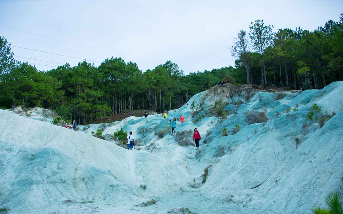
Researchers have confirmed that the soil remains safe for tourist exploration, despite its unusual mineral content. The copper sulfate concentrations, while responsible for the striking coloration, pose no health risks to visitors who follow basic safety guidelines.
Traverse Route from Kamanbaneng Peak
The trail from Kamanbaneng Peak to Kaman-Utek Hills descends through diverse terrain, including areas dotted with sharp rock formations and wild berry trees. The downward path proves relatively easy, with numerous pine trees lining the route and natural log bridges facilitating stream crossings.
We took our time during this section, using the descent as an opportunity to relax and breathe in the incredibly fresh mountain air. The change in elevation provides different perspectives on the surrounding landscape and ecosystem.
Route Highlights:
- Sharp limestone formations creating natural sculptures
- Wild berry trees (seasonal fruit availability)
- Pine forest corridors with natural lighting
- Small stream crossings with rustic log bridges
- Gradual elevation changes revealing different plant communities
Photography Tips for Blue Soil Hills
The unique coloration of Kaman-Utek Hills creates exceptional photography opportunities, especially for visitors interested in capturing unusual natural phenomena. The blue soil provides striking contrast against green vegetation and traditional earth tones.
Photography Recommendations:
- Visit during slightly overcast conditions for even lighting
- Bring a spray bottle to enhance soil color saturation
- Use polarizing filters to reduce glare and enhance colors
- Experiment with close-up texture shots and wide landscape views
- Consider golden hour timing for warm light contrasts
The area offers excellent opportunities for group photos and creative compositions that showcase the unique geological features alongside traditional mountain landscapes.
Practical Information and Costs
Guide Fees and Transportation
Current Guide Rates (2025):
- Marlboro Hills only: ?800 for groups up to 10 people
- Combined Marlboro Hills-Blue Soil Hills traverse: ?1,600 for groups up to 10 people
- Transportation to jump-off point: ?650-1,300 depending on route and group size
Guide services prove essential not only for navigation but also for supporting the local economy. Local guides possess extensive knowledge about the area’s history, geology, and safety considerations that significantly enhance the experience.
Contact the Sagada Municipal Tourism Office for current rates and guide availability. Booking advance reservations during peak seasons (December-February, March-May) ensures guide availability.
Accommodation Options in Sagada
Sagada offers diverse accommodation options ranging from budget hostels to mid-range hotels. Most visitors stay in town proper, which provides easy access to various attractions including our featured Sagada Cave Connection adventure.
Recommended Areas:
- Town proper for convenience and restaurant access
- Surrounding barangays for quieter, more authentic experiences
- Eco-lodges for environmentally conscious travelers
Many accommodations can arrange early morning transportation to Kamanbaneng Peak, making logistics smoother for sunrise treks.
Safety Tips and Precautions
Mountain hiking always requires appropriate safety precautions, even on relatively easy trails like Kamanbaneng Peak. Follow these essential safety guidelines:
Before You Go:
- Inform someone about your planned route and expected return time
- Check weather conditions and postpone if severe weather threatens
- Ensure adequate physical fitness for moderate hiking
- Verify guide credentials through official tourism office
During the Hike:
- Stay on designated trails to prevent erosion and preserve vegetation
- Follow your guide’s instructions and safety recommendations
- Maintain appropriate pace and take breaks as needed
- Respect local customs and Leave No Trace principles
Reference Leave No Trace principles for environmentally responsible hiking practices.
Best Time to Visit and Seasonal Considerations
Sagada’s climate varies significantly throughout the year, affecting both hiking conditions and sunrise visibility at Kamanbaneng Peak.
Optimal Seasons:
- March to May: Clear skies, minimal rainfall, comfortable temperatures
- October to December: Cool weather, excellent visibility, fewer crowds
- January to February: Coolest temperatures, possible morning frost, clear views
Challenging Seasons:
- June to September: Rainy season with muddy trails and potential cloud cover
- Peak tourist periods: December-January and March-April bring larger crowds
Plan your visit during dry season months for the best combination of weather conditions, trail accessibility, and photographic opportunities.
Alternative Sagada Adventures
While visiting Kamanbaneng Peak and Kaman-Utek Hills, consider exploring other spectacular Sagada attractions that complement your mountain adventure:
Combine your sunrise trek with our detailed Echo Valley to Bokong Falls guide for a comprehensive nature experience. The scenic waterfall trek offers a refreshing contrast to summit hiking and showcases Sagada’s diverse landscapes.
For cultural immersion, our Traditional Tattoo in Buscalan article provides insights into authentic indigenous art traditions that have been practiced in the region for generations.
Other notable Sagada attractions include:
- Sumaguing Cave spelunking adventures
- Hanging Coffins cultural site
- Bomod-ok Falls trekking
- Orange picking experiences (seasonal)
The Philippine Department of Tourism and Mountain Province Official Website provide additional information about regional attractions and current travel advisories.
Conclusion
Our adventure ascending Kamanbaneng Peak and exploring Kaman-Utek Hills created unforgettable memories that perfectly capture Sagada’s natural beauty. From the spectacular sunrise views revealing the Cordillera mountains to the otherworldly blue soil formations, this combined trek offers diverse experiences that satisfy both adventure seekers and nature photographers.
The relatively easy accessibility makes these destinations suitable for hikers of various skill levels, while the unique geological and scenic features provide plenty of material for social media sharing and personal reflection. The experience reminds us why Sagada continues to attract travelers seeking authentic mountain adventures in the Philippines.
Whether you’re planning a solo journey, romantic getaway, or group adventure, the Kamanbaneng Peak and Kaman-Utek Hills traverse delivers the perfect combination of natural wonder, physical challenge, and cultural immersion that defines the best of Philippine mountain tourism.
Frequently Asked Questions
How long does it take to hike Kamanbaneng Peak?
The hike to Kamanbaneng Peak takes approximately 45 minutes to 1 hour from the jump-off point, depending on your pace and fitness level.
What time should I start hiking for sunrise?
Start your hike around 4:30-5:00 AM to reach the summit before sunrise, which typically occurs between 6:00-6:30 AM.
How much does it cost to visit Kamanbaneng Peak and Kaman-Utek Hills?
Guide fees are approximately ?800 for up to 10 people for Marlboro Hills only, or ?1,600 for the combined Marlboro Hills-Blue Soil Hills traverse. Transportation costs around ?650-1,300 depending on your itinerary.
Can I visit both Kamanbaneng Peak and Kaman-Utek Hills in one day?
Yes, most visitors do the traverse from Kamanbaneng Peak to Kaman-Utek Hills in a single day trip, which takes about 3-4 hours total.
Is it safe to visit the blue soil at Kaman-Utek Hills?
Yes, researchers have confirmed that the blue soil is safe for tourists to explore, though it’s caused by copper sulfate content in the soil.
Do I need a guide to hike Kamanbaneng Peak?
While the trail is relatively easy, hiring a local guide is recommended for safety and to support the local community. Guides are required for the Blue Soil Hills portion.
What should I wear for the hike?
Wear comfortable hiking shoes, warm layers for early morning cold, and bring a waterproof jacket. Temperatures can drop to 10-15°C before sunrise.
Ready to explore more of Sagada’s natural wonders? Check out our guides to Sagada Cave Connection, Echo Valley to Bokong Falls, and Traditional Tattoo in Buscalan for a complete Mountain Province adventure.
If you are building an itinerary across the region, this destination pairs naturally with Mount Daraitan Echo Valley Bokong Falls Mount Batur Mount Pulag.
This Sagada trip is real fun because your troop is with you. Photos here are definitely breath-taking, the views are to-die for. The bluish color of the soil of the Kaman-Utek hills was majestic looks like the color formation was from a snow but from the chemicals. Looking forward to more of your adventures.
Thanks. It’s fun to travel with your troop.
I want to go to Sagada, and this is the first destination I will go to after this pandemic. Lots of videos and travel guides make me super excited.